How Are Inspectors Using 3D Maps Made by the Elios 3?
One of the most significant upgrades from the Elios 2 to the Elios 3 is the integration of a LiDAR sensor, which enables the creation of detailed 3D maps. This advancement allows users to capture and visualize complex environments with precision, making inspections more efficient and safer than ever before.
The LiDAR data collected by the Elios 3 generates a real-time 3D Live Map as the drone navigates through an asset, as shown in the image below. This data can also be processed later using GeoSLAM’s software to produce high-accuracy 3D models for further analysis.
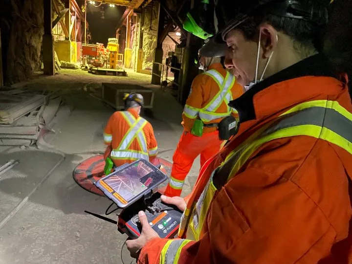
The 3D Live Map is visible in the lower right hand corner of the tablet
Since its launch, the Elios 3 has been widely praised by inspectors around the world for its 3D mapping capabilities, especially in confined spaces. The ability to create accurate 3D representations of hard-to-reach areas is transforming how inspections are conducted, offering new levels of detail and insight. These 3D maps help inspectors: - Visualize the exact location of defects within assets. - Fly in extremely dusty environments where the visual feed is unclear. - Measure stockpiles faster, cheaper, and more safely. - Ensure complete coverage when inspecting uniform structures like tanks and boilers. Despite the positive feedback, many users are still exploring the full potential of 3D mapping in the field. To help make this technology more accessible, here are six real-world use cases demonstrating how the Elios 3's 3D mapping is making a difference. **1. Helping Decommission an Old Power Plant** Industry: Power Generation At a decommissioned power plant owned by Vattenfall, the Elios 3 was used to map "no-go" zones that were unsafe for human entry. The drone created both real-time and post-flight 3D models, giving engineers critical insights into the site's structure.Read the full case study.
**2. Finding the Cause of an Ore Pass Hangup** Industry: Mining A mining operation used the Elios 3 to quickly locate a clog in an ore pass, saving time and resources. What had taken two months of drilling was solved in just ten minutes using the drone’s 3D mapping.Read the full case study.
**3. Improving Efficiency in Stockpile Measurement at a Cement Plant Silo** Industry: Cement A French cement plant used the Elios 3 to measure clinker stockpiles efficiently. In 30 minutes, they collected and processed data to get precise measurements, even in low-visibility conditions.Read the full case study.
**4. Mapping Unknown Areas of an Old Mine** Industry: Mining Luxembourg’s Mines Division used the Elios 3 to map an old slate quarry being converted into a museum. The LiDAR sensor allowed them to create detailed 3D maps quickly and accurately.Read the full case study.
**5. Planning, Tracking Changes Over Time, and Geolocating Defects for Water Tanks and Wastewater Infrastructure** Industry: Water/Wastewater Infrastructure Lausanne’s Water Department used the Elios 3 to track changes over time and geolocate defects in water tanks. The 3D maps provided a safe and accurate way to monitor infrastructure without entering confined spaces.Read the full case study.
**6. Improving Safety and Accuracy for Stockpile Measurements at a Salt Mine** Industry: Mining At a salt mine in Germany, the Elios 3 replaced manual methods for measuring stockpiles. It eliminated the need for workers to climb dangerous salt cones, improving both safety and accuracy.Read the full case study.
Want to learn more about the Elios 3? Watch a demo now.
Knitted Mesh,Knitted Wire Mesh,Knit Mesh,Knitted Copper Mesh
glorybest industry co.,ltd , https://www.hbglorybest.com